
World Climate Zones
World Climate Zones
Have you ever wondered why one area of the world is a desert, another a grassland, and another a rainforest? Why are there different forests and deserts, and why are there different types of life in each area? The answer is climate.Climate is the characteristic condition of the atmosphere near the earth's surface at a certain place on earth. It is the long-term weather of that area (at least 30 years). This includes the region's general pattern of weather conditions, seasons and weather extremes like hurricanes, droughts, or rainy periods. Two of the most important factors determining an area's climate are air temperature and precipitation.
World biomes are controlled by climate. The climate of a region will determine what plants will grow there, and what animals will inhabit it. All three components, climate, plants and animals are interwoven to create the fabric of a biome.
Some facts about climate
The sun's rays hit the equator at a direct angle between 23 ° N and 23 ° S latitude. Radiation that reaches the atmosphere here is at its most intense.
In all other cases, the rays arrive at an angle to the surface and are less intense. The closer a place is to the poles, the smaller the angle and therefore the less intense the radiation.
Our climate system is based on the location of these hot and cold air-mass regions and the atmospheric circulation created by trade winds and westerlies.
Trade winds north of the equator blow from the northeast. South of the equator, they blow from the southeast. The trade winds of the two hemispheres meet near the equator, causing the air to rise. As the rising air cools, clouds and rain develop. The resulting bands of cloudy and rainy weather near the equator create tropical conditions.
Westerlies blow from the southwest on the Northern Hemisphere and from the northwest in the Southern Hemisphere. Westerlies steer storms from west to east across middle latitudes.
Both westerlies and trade winds blow away from the 30 ° latitude belt. Over large areas centered at 30 ° latitude, surface winds are light. Air slowly descends to replace the air that blows away. Any moisture the air contains evaporates in the intense heat. The tropical deserts, such as the Sahara of Africa and the Sonoran of Mexico, exist under these regions.
Seasons
The Earth rotates about its axis, which is tilted at 23.5 degrees. This tilt and the sun's radiation result in the Earth's seasons. The sun emits rays that hit the earth's surface at different angles. These rays transmit the highest level of energy when they strike the earth at a right angle (90 °). Temperatures in these areas tend to be the hottest places on earth. Other locations, where the sun's rays hit at lesser angles, tend to be cooler.
As the Earth rotates on it's tilted axis around the sun, different parts of the Earth receive higher and lower levels of radiant energy. This creates the seasons.
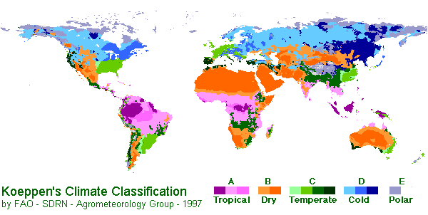
Three basic climate groups.
Three major climate groups show the dominance of special combinations of air-mass source regions.
Group I
Low-latitude Climates: These climates are controlled by equatorial a tropical air masses.
- Tropical Moist Climates (Af) rainforest
Rainfall is heavy in all months. The total annual rainfall is often more than 250 cm. (100 in.). There are seasonal differences in monthly rainfall but temperatures of 27°C (80°F) mostly stay the same. Humidity is between 77 and 88%.
High surface heat and humidity cause cumulus clouds to form early in the afternoons almost every day.
The climate on eastern sides of continents are influenced by maritime tropical air masses. These air masses flow out from the moist western sides of oceanic high-pressure cells, and bring lots of summer rainfall. The summers are warm and very humid. It also rains a lot in the winter
- Average temperature: 18 °C (°F)
- Annual Precipitation: 262 cm. (103 in.)
- Latitude Range: 10° S to 25 ° N
- Global Position: Amazon Basin; Congo Basin of equatorial Africa; East Indies, from Sumatra to New Guinea.
- Wet-Dry Tropical Climates (Aw) savanna
A seasonal change occurs between wet tropical air masses and dry tropical air masses. As a result, there is a very wet season and a very dry season. Trade winds dominate during the dry season. It gets a little cooler during this dry season but will become very hot just before the wet season.
- Temperature Range: 16 °C
- Annual Precipitation: 0.25 cm. (0.1 in.). All months less than 0.25 cm. (0.1 in.)
- Latitude Range: 15 ° to 25 ° N and S
- Global Range: India, Indochina, West Africa, southern Africa, South America and the north coast of Australia
- Dry Tropical Climate (BW) desert biome
These desert climates are found in low-latitude deserts approximately between 18° to 28° in both hemispheres. these latitude belts are centered on the tropics of Cancer and Capricorn, which lie just north and south of the equator. They coincide with the edge of the equatorial subtropical high pressure belt and trade winds. Winds are light, which allows for the evaporation of moisture in the intense heat. They generally flow downward so the area is seldom penetrated by air masses that produce rain. This makes for a very dry heat. The dry arid desert is a true desert climate, and covers 12 % of the Earth's land surface.
- Temperature Range: 16° C
- Annual Precipitation: 0.25 cm (0.1 in). All months less than 0.25 cm (0.1 in).
- Latitude Range: 15° - 25° N and S.
- Global Range: southwestern United States and northern Mexico; Argentina; north Africa; south Africa; central part of Australia.
Group II
Mid-latitude Climates: Climates in this zone are affected by two different air-masses. The tropical air-masses are moving towards the poles and the polar air-masses are moving towards the equator. These two air masses are in constant conflict. Either air mass may dominate the area, but neither has exclusive control.
- Dry Midlatitude Climates (BS) steppe
Characterized by grasslands, this is a semiarid climate. It can be found between the desert climate (BW) and more humid climates of the A, C, and D groups. If it received less rain, the steppe would be classified as an arid desert. With more rain, it would be classified as a tallgrass prairie.
This dry climate exists in the interior regions of the North American and Eurasian continents. Moist ocean air masses are blocked by mountain ranges to the west and south. These mountain ranges also trap polar air in winter, making winters very cold. Summers are warm to hot.
- Temperature Range: 24° C (43° F).
- Annual Precipitation: less than 10 cm (4 in) in the driest regions to 50 cm (20 in) in the moister steppes.
- Latitude Range: 35° - 55° N.
- Global Range: Western North America (Great Basin, Columbia Plateau, Great Plains); Eurasian interior, from steppes of eastern Europe to the Gobi Desert and North China.
- Mediterranean Climate (Cs) chaparral biome
This is a wet-winter, dry-summer climate. Extremely dry summers are caused by the sinking air of the subtropical highs and may last for up to five months.
Plants have adapted to the extreme difference in rainfall and temperature between winter and summer seasons. Sclerophyll plants range in formations from forests, to woodland, and scrub. Eucalyptus forests cover most of the chaparral biome in Australia.
Fires occur frequently in Mediterranean climate zones.
- Temperature Range: 7 °C (12 °F)
- Annual Precipitation: 42 cm (17 in).
- Latitude Range: 30° - 50° N and S
- Global Position: central and southern California; coastal zones bordering the Mediterranean Sea; coastal Western Australia and South Australia; Chilean coast; Cape Town region of South Africa.
- Dry Midlatitude Climates (Bs) grasslands biome
These dry climates are limited to the interiors of North America and Eurasia.
Ocean air masses are blocked by mountain ranges to the west and south. This allows polar air masses to dominate in winter months. In the summer, a local continental air mass is dominant. A small amount of rain falls during this season.
Annual temperatures range widely. Summers are warm to hot, but winters are cold.
- Temperature Range: 31 °C (56°F).
- Annual Precipitation: 81 cm. (32 in.).
- Latitude Range: 30° - 55° N and S
- Global Position: western North America (Great Basin, Columbia Plateau, Great Plains); Eurasian interior.
- Moist Continental Climate (Cf) Deciduous Forest biome
This climate is in the polar front zone - the battleground of polar and tropical air masses. Seasonal changes between summer and winter are very large. Daily temperatures also change often. Abundant precipitation falls throughout the year. It is increased in the summer season by invading tropical air masses. Cold winters are caused by polar and arctic masses moving south.
- Temperature Range: 31 °C (56 ° F)
- Average Annual Precipitation: 81 cm (32 in).
- Latitude Range: 30° - 55° N and S (Europe: 45° - 60° N).
- Global Position: eastern parts of the United States and southern Canada; northern China; Korea; Japan; central and eastern Europe.
|
Group III
|
|
|
|
|
|
|
|
|
|
Bibliography:
Strahler, Arthur N., Strahler, Arthur H., Elements of Physical Geography. John Wiley & Sons, 1984.


